
Monitoring Network
CMWC operates a network of groundwater level monitors across Chehalem Mountain, giving residents their own data to use in the legal and advocacy processes that affect their water supply.
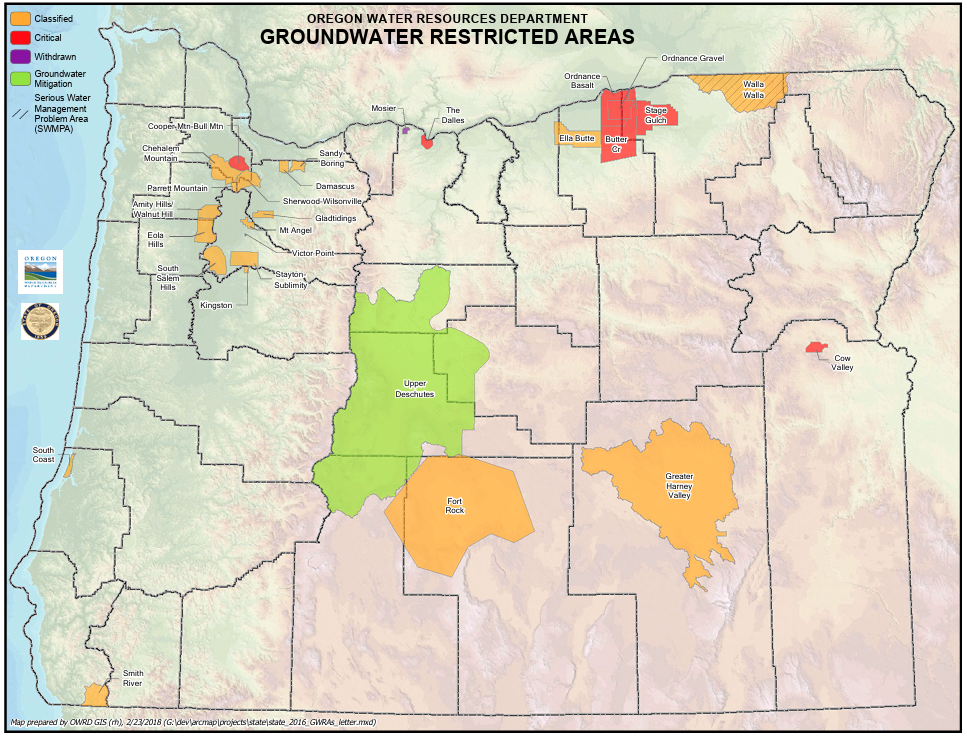
Oregon has officially recognized Chehalem Mountain's groundwater is under stress.
In 1991, the Oregon Water Resources Department designated Chehalem Mountain as a Groundwater Limited Area: a formal classification triggered by excessive declines in groundwater levels across the Columbia River Basalt aquifer system.
This designation established more restrictive permitting for new groundwater uses. It hasn't gone away. Independent monitoring data is one of the most powerful tools a community like this has to stay ahead of what comes next.
Our Monitoring Network
-
Each monitor in our network records the depth to groundwater in a private well — continuously, around the clock.
What we're watching for most closely is decline — specifically, whether water levels drop during the dry season and fail to fully recover when the rains return. That pattern, observed over time, is a warning sign that the aquifer system is being drawn down faster than it can replenish.
-
Every water rights application in Oregon goes through a public process. Applicants typically hire technical and legal consultants who reference existing state and agency data to support their case. Our monitoring network gives the community independent locally collected data owned by the people who live here.
A single residential well reading in the vicinity of the Jaquith Road marijuana farm water right application played a significant role in the restrictive outcome of that case. One well. One outcome that protected an entire community. That's exactly why CMWC consulted directly with OWRD when distributing our monitors — to make sure the data is as credible and useful as possible to everyone involved.
-
The Wellintel monitors record levels automatically and continuously. Residents in the network can access their own data at any time through a secure online portal. The data belongs to them — CMWC uses it with their permission to inform our advocacy work.
Where We’re Monitoring
The network spans the full extent of Chehalem Mountain — from the western ridgeline near Laurelwood to the eastern slopes above Newberg and Sherwood. Sensors were distributed in consultation with OWRD to ensure the data is as geographically representative — and legally useful — as possible.
The map shows active Wellintel sensor locations across the Chehalem Mountain monitoring network. Well locations are identified by resident last name. One sensor (Grant) was removed following the initial monitoring period — data from that well informed early network calibration.
What the Data Shows
Chehalem Mountain's aquifer doesn't behave the same way everywhere. The geology varies, the hydrology varies, and the vulnerability to new water demands varies. That's exactly why location matters — and why a distributed monitoring network tells us things a single well reading never could. These two wells illustrate the contrast most clearly.
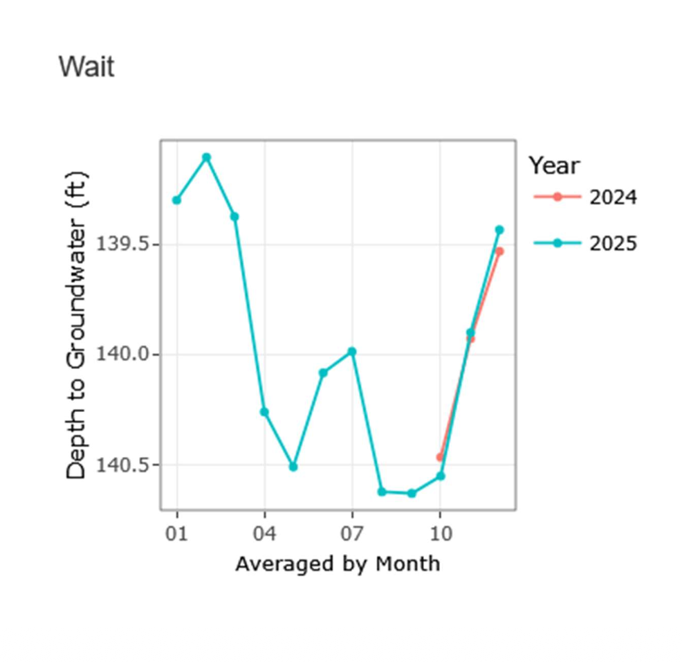
Less than 2ft of variation — but that's not reassuring.
Juliette's monitor sits on the north side of the mountain in an area not identified as a recharge zone. The seasonal variation here is strikingly different — less than 2 feet across the full year. At first glance that might seem reassuring. It isn't necessarily. In an area without active recharge, the aquifer isn't being replenished the same way — which means it has less capacity to absorb new demands without permanent decline. Smaller swings reflect a different kind of vulnerability, not stability. This data helps CMWC understand where new water uses would have the most impact — and where we need to be most vigilant.
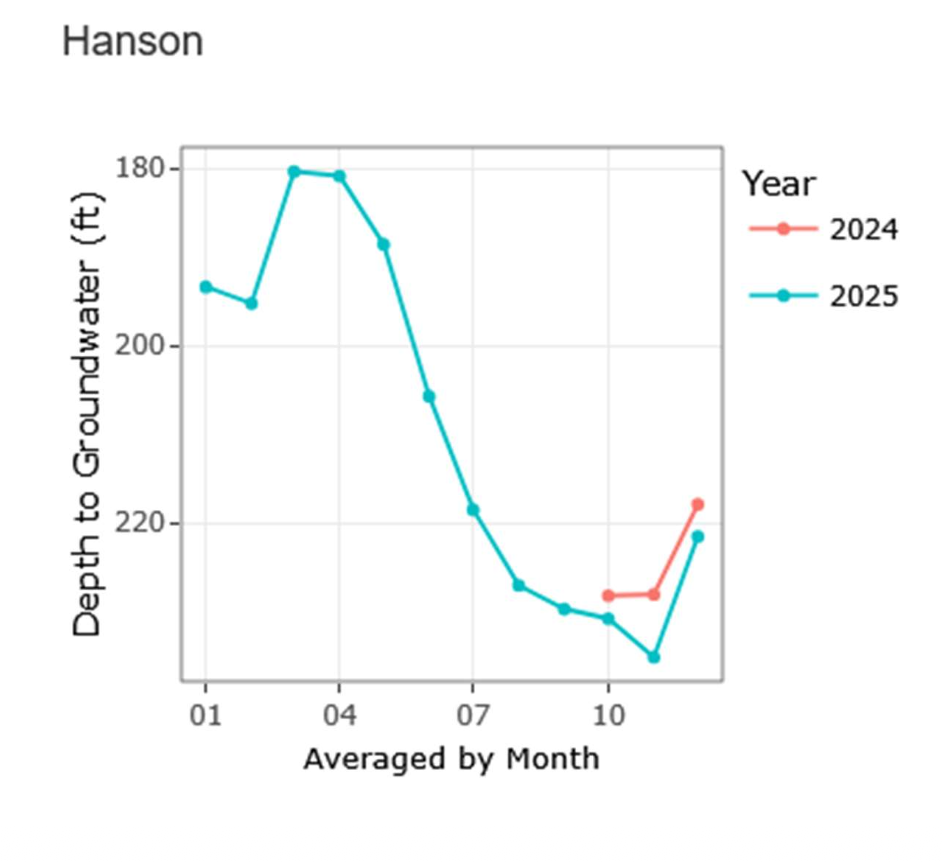
A ~40ft seasonal swing — with full recovery each year.
Karyn's monitor sits in an area identified by local hydrogeologists as a recharge zone — a place where seasonal rainfall actively replenishes the aquifer from above. The data reflects that clearly. Water levels drop through the dry summer months — falling roughly 40 feet from their wet-season high — then climb back up as the rains return, recovering fully each year. That full seasonal recovery is the sign of a healthy, functioning aquifer. It means this part of the mountain is still doing what it's supposed to do. The question is how long that holds if new demands keep increasing.
Is your well on Chehalem Mountain?
CMWC's monitoring network depends on willing residents who are open to having a sensor installed in their well. If you live within the Chehalem Mountain Groundwater Limited Area and are interested in participating, we'd love to hear from you. Your data stays yours — and it helps protect the entire community.